A wellpath is defined as a single wellbore trajectory drilled from a specific surface location as defined on the Wellpath tab of the Wellpath form (shown above).
If a particular sequence of depths is re-drilled, a new wellpath (sidetrack) must be generated in order to capture its data. This does not apply when drilling cement or milling in an existing wellbore. Parameters for such operations are not intended to be registered under the wellpath as there is no new hole being drilled. Purely for informational reasons, drilling parameters for these operations can be recorded in the daily activities.
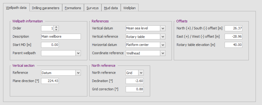
Each wellpath is defined by a Path Order, a Start Depth and a Description.. The Path Order is provided to logically sort the order in which the paths (trajectories) were drilled. The Start Depth and Description should be self-explanatory, but it should be noted that the Start Depth should be the depth at which the previous wellpath, if any, was exited (i.e. the sidetrack point). The Parent Wellpath field should be used to define the wellpath from which the trajectory was started. Any cement drilled in the parent wellbore (i.e. when sidetracking of a cement plug) should be excluded.
Typically, on a new well, the first wellpath has a path order of 1 (or 0 if desired), a starting depth of 0 m/ft and a description like "Main wellbore" or "Primary wellbore". Subsequent sidetracks may than be labeled in a logical manner, such as "Sidetrack 1", "Well Name S1", etc.
 WellRep is not intended to be used as a wellbore positioning tool (such as Landmark Compass). The data on this tab is entered for informational purposes only. Only some of it (e.g. Offsets and Vertical Section Plane Direction) are used in survey or wellplan calculations.
Under References, a datum and a reference (vertical and horizontal) may be entered. A datum is a point in that is used to determine the wellbore position globally. Effectively it's a reference point or plane that will not change over time and is independent of the well. Both vertically and horizontally the survey and wellplan data may be referenced to the well position or the specified datum. For example, Measured Depths can be referenced to Rotary Table or Datum (e.g. Ground Level, Mean Sea Level, etc.). Coordinates may also be calculated from Wellhead or from Datum (e.g. Platform Reference Point).
|
Copyright © 2023 Softdrill NL |